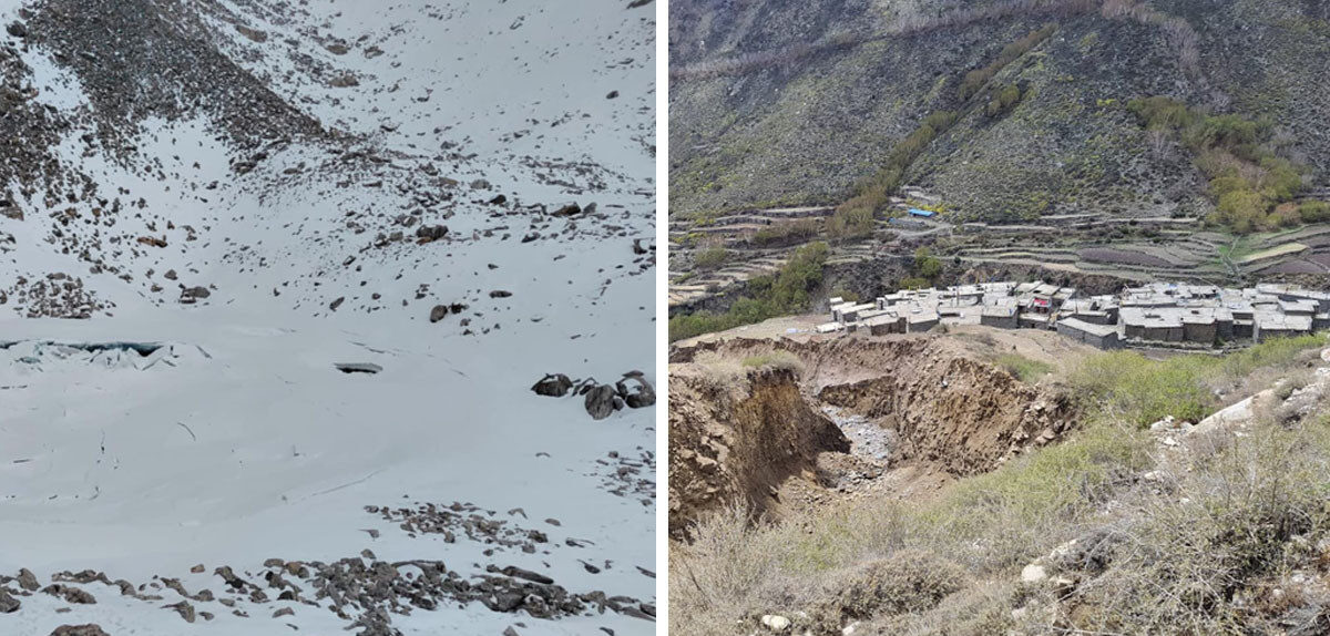
Til village in Namkha Rural Municipality-6, Northern Humla, is known for its beautiful snow-capped mountain range, the Tiljung River flowing nearby, ancient Buddhist monasteries, and fertile fields.
Til Village
However, on May 15 (Jestha 1), a massive glacier flood originating from the hilltops drastically changed the identity of Til village. The settlement near the river is now at high risk as the riverbed has deepened, carrying away large boulders. Without the onset of monsoon, the villagers faced an unexpected disaster and are currently in distress.
“The flood struck around midnight and scared the entire village. People were just about to sleep when the river suddenly roared fiercely. Everyone ran for their lives and reached higher ground. It was only the next day that we understood the extent of the damage,” said Paljor Tamang, ward chairperson of Namkha Rural Municipality Ward No. 6.
Tamang learned about the flood only on Friday, the next day after the incident. He informed the municipality chairperson, Prem Bahadur Lama, and immediately went up to Til village. Tamang’s own village, Halji, lies just a little lower and to the east of Til village. At 3,984 meters, Til village is home mainly to the Lama ethnic group, who engage in farming and trade.
Out of around 50 households in Gujumuj village, only 18 remain inhabited, with many people living elsewhere for business. When Tamang arrived, the Tiljung River had calmed but left large amounts of debris. The riverbed was much deeper than before. “The people were terrified. Nothing like this had been seen before. It was as if a mountain had broken,” he said.
The glacier flood destroyed a 15 kW hydropower project, four or five wooden bridges, and irrigation canals. The river damaged two houses and left others at risk. “At first, I helped evacuate locals to a safe place near the Himalayan School,” said Tamang. “Then we started investigating the cause of the flood.”
From Halji to Til village took him about three hours. The road is accessible by vehicle only in winter. The flood also destroyed that road, so he had to take a longer route, reaching Til village by 9 am.
Til village residents remain waiting for rescue and relief. Three days after the flood, security forces, including the Armed Police, arrived to assess damages and then returned. Currently, there has been no rain in Til village. The river remains loud and restless, causing great fear among residents.
Thirty-three displaced locals are sheltering inside the school. The government has yet to determine the exact cause of the flood. Ward chairperson Paljor himself sent two locals to the glacier source area. They spent eight hours on Monday to reach and return, reporting two glaciers had broken and bringing photos. Experts will study these findings.
“The situation resembles a glacial lake outburst flood,” said Paljor. Locals are terrified upon learning a glacier lake exists above their village, something they had never known before. Because there was no reason to visit that area, no one had gone there. “There is fear that this will happen again, and that the whole settlement might be washed away. The current flood has already put the village at risk,” he said.
According to locals, two glacier lakes appeared to have burst in the northwest area above Tiljung hill. While there is snow in the upper area, there is no water on the lower surface, which they suspect was the source of the flood. Google images also show some glaciers in the Tiljung hill area, but no previous study existed on whether there were lakes.
“We did not know about the lakes. Since the lakes started to burst, it raised concerns about more risks. We are worried about how to protect the village,” Paljor said. He complained about a lack of immediate support and attention from the federal government, although the municipality is trying its best. Dinesh Prasad Bhatta, Executive Chief of the National Disaster Risk Reduction and Management Authority (NDRRMA), said studies are underway to understand how the flood with debris occurred.
Since the authority lacks experts to study glacial lake outburst floods, they are conducting research with help from the International Centre for Integrated Mountain Development (ICIMOD). “I learned of the incident on May 15. I immediately requested ICIMOD to study satellite images of the glaciers above Tiljung to detect changes,” Bhatta said. He officially requested the study on Sunday.
He said rescue, relief, and rehabilitation efforts are ongoing through the district disaster office, but security forces cannot be sent to the suspected lake burst area, located at about 5,400 meters altitude. After receiving news of the lake burst, some have suggested helicopter reconnaissance, which NDRRMA is awaiting ICIMOD’s report on. ICIMOD will analyze satellite images taken before and after the flood to identify changes in the glacial lakes. Based on that, we will conduct further studies,” he said.
Narayan Pandey, Chief District Officer of Humla, said the cause of the flood is still uncertain. Some locals have returned from the site but cannot conclusively say it was a lake burst based on photos. Recently, the permafrost (permanently frozen ground) around glaciers has weakened, which normally helps hold lakes like a cemented dam. Rising temperatures cause ice and frozen soil and rock to weaken, increasing the risk of sudden lake bursts.
Weakening permafrost may have allowed water to seep from rocky areas, causing large floods that melted and washed away permafrost in the flood zone. Pandey echoed these concerns. “There is a possibility that water seeped in or an explosion occurred. We will confirm after the study. Right now, we are focused on rescue and relief,” he said.
Dr. Arun Bhakta Shrestha, Senior Advisor on Climate and Environmental Risk at ICIMOD, said glacier lakes in the area have shown instability before. Previously, there were glacier lake floods in Halji of Humla. He suspects the flood may also have been caused by smaller ice avalanches rather than a big lake burst, but said it is too early to say without studying.
“We are collecting satellite images before and after the flood and will analyze them,” he said. He also highlighted the need for flood early warning systems for small streams, rivers, and glacier lakes in the area. “Without such systems, people don’t know when floods will come. Here too, the flood struck at night,” he said.
Former Executive Chief Anil Pokharel of NDRRMA said there have been four glacier lake bursts in Gorkha, Solukhumbu, Dolakha, and Humla in the past year, which is a warning of growing climate crisis in the Himalayas.
“These events show our glaciers and lakes are becoming increasingly risky and prone to bursts,” he said. “The glacier lakes in the Koshi river basin are especially at risk and attract international attention when they burst.” He noted that western regions receive less attention despite risks. “While dialogues on Everest continue, a glacier lake burst has occurred in Humla. We must bring this issue to international forums.”